All pictures © 1970-2010, Peter Marshall.
Contact Peter Marshall
for permission for use, high res files and fees.
The Lea Valley
London's Second River - The River Lea (or Lee)
1981-date - including the London 2012 Olympic site
photographs by Peter Marshall
The River Lea
The River Lea runs from Leagrave at the edge of Luton into
Hertfordshire and the south to enter Greater London near Waltham Cross. (Another
stream starts two miles to the west at Houghton Regis but seems seldom to
be considered as the source.) It continues south through Enfield Lock, Ponders
End, Brimsdown and Tottenham Hale to Stratford. The spellings Lea
and Lee are both in current use, but the river is more often
called the River Lea (anciently sometimes the River
Ley) and the navigation the Lee Navigation.
From Hertford, the River is sometimes a part of the Lee Navigation,
and sometimes runs parallel to it, at times in a complicated mass of streams
and flood channels - as in the area which is to be the site of the London
Olympics in 2012. This includes the Old
River Lea, Three Mills River, Prescott Channel,
Channelsea River, City Mill River and Waterworks
River.
Water taken from the Lea between Hertford and Broxbourne
also forms the basis of the New River, constucted to bring
clean drinking water to London in the 17th century.
The Lea Valley was for years the industrial centre of London and home to
many inventions. Here was the first monorail (horse-drawn), the driving power
behind the motorcycle industry, the great railway works, buses, guns, gunpowder,
chemicals, shipbuilding and much more. In the first half of the 20th century
this was the UK's 'silicon valley''. The modern electronics revolution began
with the invention of the diode by Ambrose Fleming at Ediswan in Ponders End
in 1904, and companies including Thorn, MK, Belling, Ferguson (and much later,
Amstrad) set up factories here.
Chaim Weizmann's work with others at Three Mills on the fermentation of
grains to produce acetone played a vital part in munitions manufacture in
the First World War and led to the Balfour declaration, leading to the setting
up of Israel (he became its first president in 1949.)
South of Stratford, there are two routes to the Thames. The river itself
runs down through the tidal Bow Creek, with its dramatic
bends sweeping around the factory of Pura Foods and on under a tidal barrier
to meet the main river at Trinity Buoy Wharf, more or less opposite the Millennium
Dome.
Most small boats prefer the easier route of the Limehouse Cut,
leading now to the Regents Canal Dock (which can also be
reached by turning down the Hertford Union Canal at Hackney
Wick, which links the Lee Navigation to the Regents Canal. From the dock,
also known as Limehouse Dock, a single lock now leads the
the River Thames.
The Limehouse Cut, constructed in 1770, had its own lock
to the Thames until relatively recently. It was only in 1969 that a new short
lenght of canal was cut, taking the Cut into the Regents Canal Dock
(also called Limehouse Dock.)
This site will look at all of the waterways listed above, and also some of
the other flood channels, the Old River Lea and the Bow
Back rivers and other associated waterways, and the area surrounding
the rivers, especially in the area of the London Olympic 2012 site.
1980-92 black and white pictures
1980s Colour pictures
2000 to date (colour)
My other London web sites
London's Industrial Heritage
My London Diary
The Buildings of London
On Photography
>Re:PHOTO
33d56: The source of the River Lea,
Leagrave, near Luton,. Bedfordshire.
December 1982.TL 061 248
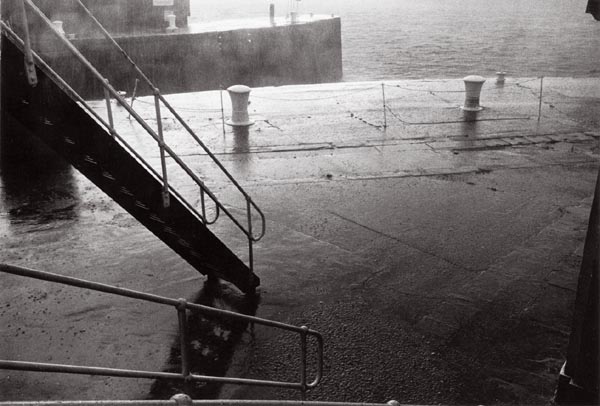
33f33: Regents Canal Dock entrance to
River Thames during torrential rain,
October 1982. TQ 363 808
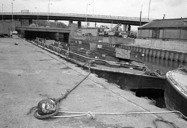
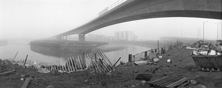
29t26: The last days of commercial traffic on the Lee Navigation. October 1981, Bow Flyover.
My Photographs
I first photographed the Lee Navigation in the early 1980s,
when a few commercial barges were still in use. Within months they had gone.
It was also a time when many of the larger manufacturing industries which
had occupied the Lea Valley were closing down, as Thatcher
closed down our productive base and shifted decisively towards the UK as a
service economy. At times I very much felt I was recording a post-industrial
wasteland.
Since then, I've returned to the Lea Valley and photographed
it again at some depth at roughly ten year intervals. I've worked in both
black and white and colour, and, more recently using panoramic cameras and,
in the past few years working with digital. Only a few of my pictures are
on this web site, and there are quite a few I hope to add when I get time,
particularly from the 1990s. There are also currently few images since 2005
on this site, but quite a few can be seen on another of my sites, My
London Diary.
With the redevelopment of the lower Lea Valley to accomodate
the needs of the 2012 London Olympics, much of the unique
nature of the area and its rivers is likely to be lost, covered in acres of
concrete and much of the smaller rivers encased in conduits. The current time
seems a particularly important one to record.
Many of the pictures from this site are among the 244 in my Blurb Book
Pictures are available for commercial use - please email
me
for terms and hi-res files..
Permission is normally granted for suitable non-commercial
use without cost - please email the above address. I also welcome comments
and questions about the work.